

It looks like those Groundhog Day predictions of a long winter on Long Island may be coming true.
No sooner did a wintry mix of snow, sleet, and freezing rain make for a slippery Thursday commute with widespread school delays, a winter storm dumped more than five inches of snow on parts of the region, National Weather Service (NWS) reports.
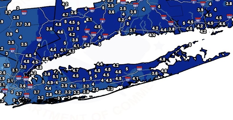
The highest accumulation in Nassau County was in Muttontown with 5.1 inches, while Commack, Nesconset, Orient Point, Ridge, Smithtown and Hauppauge led Suffolk County with 5 inches.
There is a possibility of more snow Tuesday, Wednesday, and Saturday, but NWS has not issued any advisories for those storms and accumulation is unclear.
Here ARE the snow totals for LI in the latest storm:
NASSAU
Muttontown 5.1
Jericho 4.9
East Williston 4.4
Hicksville 4.3
N Massapequa 4.2
Syosset 4.0
Herricks 3.9
Manhasset Hills 3.9
Sea Cliff 3.8 in
Westbury 3.8
Floral Park 3.7
Plainview 3.6
Farmingdale 3.5
Hicksville 3.5
Plainview 3.5 i
Syosset 3.5
Malverne 3.2
Massapequa Park 3.2
East Meadow 3.1
Albertson 0.2
Bellmore 3.0
Bethpage 2.8
Merrick 2.8
Seaford 0.4
SUFFOLK
Commack 5.0
Hauppauge 5.0
Nesconset 5.0
Orient Point 5.0
Ridge 5.0
Smithtown 5.0
Commack 4.8
Hampton Bays 4.8
Mattituck 4.8
Port Jefferson 4.8
Centerport 4.7
Upton 4.6
Centereach 4.5
Commack 4.5
North Patchogue 4.5
Port Jefferson Station 4.5
1 N Setauket-East Seta 4.5
Smithtown 4.5
Stony Brook 4.5
Yaphank 4.5
Setauket-East Setauket 4.4
Stony Brook 4.4
E Commack 4.3
Hauppauge 4.3
Ridge 4.3
Ronkonkoma 4.3
Miller Place 4.2
Center Moriches 4.1
North Babylon 4.1
Baiting Hollow 4.0
Islip Airport 4.0
Islip Terrace 4.0
Ridge 4.0
Deer Park 3.8
East Quogue 3.6
Sayville 3.5
Patchogue 3.4
Babylon 3.3
Bayport 3.3
Islip Terrace 3.3
Amityville 3.0
Blue Point 3.0
Bay Shore 2.9
Manorville 2.9
Sayville 2.9
East Islip 2.5